Scientists Draw Maps to Stop Stink Bug Pirates
 |
|
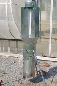
This black light trap stands guard against fruit and vegetable pests, including the brown marmorated stink bug, in a network of about 70 similar traps in New Jersey. Source: G. Hamilton, Rutgers University |
A monitoring system set up in the early 1980s to track common vegetable pests in New Jersey has led to a treasure trove of maps about a new invader, the brown marmorated stink bug (BMSB). Scientists are analyzing the maps to stop BMSB from pirating a wide range of fruit and vegetables in North America.
George Hamilton, an entomologist and extension specialist at Rutgers University, leads a team that is using this valuable store of historic information about BMSB movement to help them predict future BMSB activity across other regions.
The 2004 invasion
“In 1999, we first detected BMSB in New Jersey,” Hamilton said. “In 2004, Anne Nielsen and I monitored an invasion of BMSB as it came into Phillipsburg, New Jersey, right across the river from Allentown, Pennsylvania.” Nielsen is an extension specialist in fruit entomology at Rutgers who at the time was a PhD student studying BMSB. Since then, Hamilton and his team have followed the expansion of BMSB throughout New Jersey using a statewide network of black light traps.
Growers, working with scientists, had installed a series of 70 or more black light traps on their farms in the early 1980s, sentinels against the European corn borer and corn earworm. This integrated pest management program has been running continuously, albeit with modifications such as new computer technology, for more than 30 years.
Hamilton’s group prepares weekly statewide maps of their BMSB catches in New Jersey. These maps signal to growers where hotspots—rising numbers of BMSB and other pests—are found.
In 2004, they did what they could to warn growers to check their crops, but at the time BMSB was not classified as an agricultural pest. “What we can do now,” Hamilton said, “is more accurate hotspot identification.”
How growers use this information
Scientists use the maps to track insect counts, distance, and time. This information helps them estimate how quickly BMSB reproduces and how far it travels. The predictions about what areas may be at risk are immensely valuable for growers. As Hamilton knows, it’s hard work to go into the field, collect samples, and update the database. Yet for growers who live in areas where BMSB is getting established, these reports could mean the difference between a healthy harvest and crop losses.
One of Hamilton’s PhD students, Noel Hahn, has been studying BMSB movement in and out of orchards. In 2012 he visited orchards weekly, sampling specific trees on the borders and in the middle, and noting land-use types. He analyzes landscape features and tries to determine statistically from where BMSB is invading. Adam Wallner, a post-doctoral researcher with Rutgers trained in geospatial relationships and statistics, is working on making forecasts and predicting trends.
 |
|
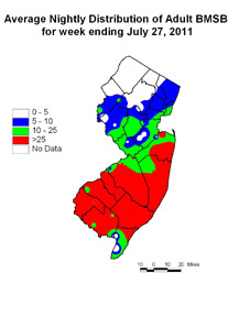
A map shows the intense BMSB activity of July 2011, illustrating the potential of mapping to warn growers about pest risk. Source: G. Hamilton, Rutgers University |
Accurate maps, useful forecasting
Today scientists seek out the maps made from historical data, wanting to understand what it looks like when BMSB invades new territory.
Hamilton has created maps of his team’s data since 2010, but he can map any year by going back to the 1980s-era vegetable and pest monitoring system. “We can look at the [2004] invasion as if it were happening in real time. We can assess how fast BMSB mates, how far it can move every year. I’m aware of only a few invading pests—the emerald ash borer would be one—where we had such an extensive monitoring system already in place.”
Bringing maps to growers on the Internet
“Three years ago,” Hamilton said, “we started publishing these maps. We put them in our newsletters. Growers can receive our newsletters, go to the website, and find BMSB hotspots. If there is a BMSB hotspot in their area, they should go out in their fields, looking themselves. If they find BMSB, they will need to make their own management decisions.”
The map research is part of a broader Coordinated Agricultural Project entitled “Biology, Ecology and Management of the Brown Marmorated Stink Bug in Specialty Crops” that has been funded through the USDA-NIFA Specialty Crop Research Initiative.
“Other states are calling us about this program,” Hamilton said, with a touch of reserved pride. “Michigan, California, and Oregon have contacted us to learn more about it.”
— by CHRIS GONZALES
The Northeastern IPM Center promotes integrated pest management for reducing risks to human health and the environment. If republishing our news, please acknowledge the source (“From Northeast IPM Insights”) along with a link to our website.