Diagnosis from the Air Could Help Farms on the Ground
 |
|
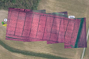
A mosaic of several aerial images gives an overview of field conditions. Source: A. Nagchaudhuri, UMDES |
You’re standing in the middle of a 50-acre field. It’s so big that it stretches to the horizon in every direction. Overhead, a Cessna 172—the ubiquitous workhorse of four-seat private planes—is flying. A Terrahawk camera mounted in its belly takes a picture. The same day, a technician hands you a GPS unit so you can walk to a precise point in the farm field and troubleshoot a potential problem spot.
“Precision Agriculture.” The expression brings to mind growers using machinery to deploy fertilizers or pest management materials in tiny, exacting amounts. But machinery can also be used to survey large expanses of farmland or environmentally sensitive areas.
The airplane could be measuring normalized difference vegetation index (NDVI), an indicator of the nitrogen needs of the plant. The data could be fed instantly to a robot control system on the ground that applies the appropriate amount of nitrogen to a plant at an exact point in a 50-acre field. This technology raises interesting possibilities for the problem of excessive nitrogen inputs in a watershed.
Aerial View
If we were to fly our plane over the Delaware, Maryland, and Virginia peninsula, called by the locals Delmarva, we’d see signs that chicken and corn feed are big agricultural industries. Upon landing at a private airstrip near the farm field, we might find someone with a background in robotics, vision control systems (of which the Hubble telescope or magnetic resonance imaging (MRI) are examples), and aviation carrying out field research with his team. This person would be Abhijit Nagchaudhuri, a professor of engineering and aviation sciences at the University of Maryland Eastern Shore.
IPM and the Nitrogen Cycle
It doesn’t offer as catchy a label as “global warming,” but human-induced changes in the global nitrogen cycle pose engineering challenges just as great and just as critical as coping with the environmental consequences of burning fossil fuels for energy. This, according to the National Academy of Engineering. Nitrogen is central in the production of food. Its management enabled the “green revolution,” huge advances in agricultural yield, but there are side effects. Excess nitrogen can cause major problems in rivers and coastal waters. Yet with too little nitrogen, plants become too weak to defend themselves from diseases, weeds, and other pests.
“In the robotics lab,” Nagchaudhuri explained, “we have cameras that help a robot identify objects and I was doing vision-based manipulation and controls work. Just like the cameras are feeding the robot with information, I began thinking about feeding a robot with information from aerial imagery.”
To this end, Nagchaudhuri has been using aerial photography to measure crop characteristics, such as the NDVI, crop water stress index, the density and number of plants, and the size of the final harvest yield. He says he envisions a day when this technology will also be used to measure pests and damage from pests.
Tech Gear to Help Farms
In the above example, when the Cessna 172 with a Terrahawk camera takes a picture, the following happens: The image is instantly georeferenced, meaning every pixel in the image has a global positioning system (GPS) reference assigned to it. A technician takes screen captures from a video and mosaics the entire field together to get a big picture for the 50 acres. He then lays the georeferenced image over a base image and scouts for problems.
Nagchaudhuri presented his work in 2015 at the International IPM Symposium in a session organized by the Northeastern IPM Center. A video of his talk is available on the web. He also coauthored a paper in 2013 in the International Journal of Applied Agricultural Research on the study of using variable rate seeding and remote sensing technologies to optimize corn yield and economic benefit on a farm.
One goal of his project: efficient nitrogen application, which will minimize groundwater pollution and optimize economic benefits for producers.
Nagchaudhuri is now using drones instead of manned aircraft to provide growers with insights into crop health. And healthy, strong crops are best able to withstand pressure from diseases, weeds, and other pests. Someday, growers may spend as much time flying aircraft to understand and manage the nitrogen cycle as they do practicing IPM.
— by CHRIS GONZALES
The Northeastern IPM Center promotes integrated pest management for reducing risks to human health and the environment. If republishing our news, please acknowledge the source (“From Northeast IPM Insights”) along with a link to our website.